作者:KLEMPERER
文章类型
- 综述总结
摘要
Crustal weak zones & Channel Flow
Lateral strain variations, and vertical strain and strength profiles in Tibet
-
总结:
Deformation & Strength &Flow
-
要点:
-
Two end-member model for HORIZONTAL deformation: (1) discrete & undeformed block & expelled between faults / (2) continuous deformation
- (1) is less plausible from GPS observations
-
VERTICAL deformation: cannot be directly measured, contentious
-
Possibility 1: vertical coherent deformation
-
Possibility 2: dominated by a more rapid ductile flow in the middle/lower crust
-
-
Lithosphere strength model:
-
Jelly-Sandwich: Stronger-(upper crust & mantle); Weaker-(lower crust); from earthquake depth analysis
-
Stronger lower crust (than upper mantle): from re-evaluation of the focal depth
-
-
Flow:
-
strength minumum
-
time scale of flow → inversely proportional to the cube with → flow layer thickness
-
transient flow ← introduction of fluids
-
lower-crustal flow conjuction with uppwe-mantle flow
-
-
Modes of crustal flow and channel flow
-
总结:
Types of flow models. Flow models & previous studies in Tibet (eastern plateau margin; NW syntaxis; Greater Himalayan Sequence)
-
要点:
-
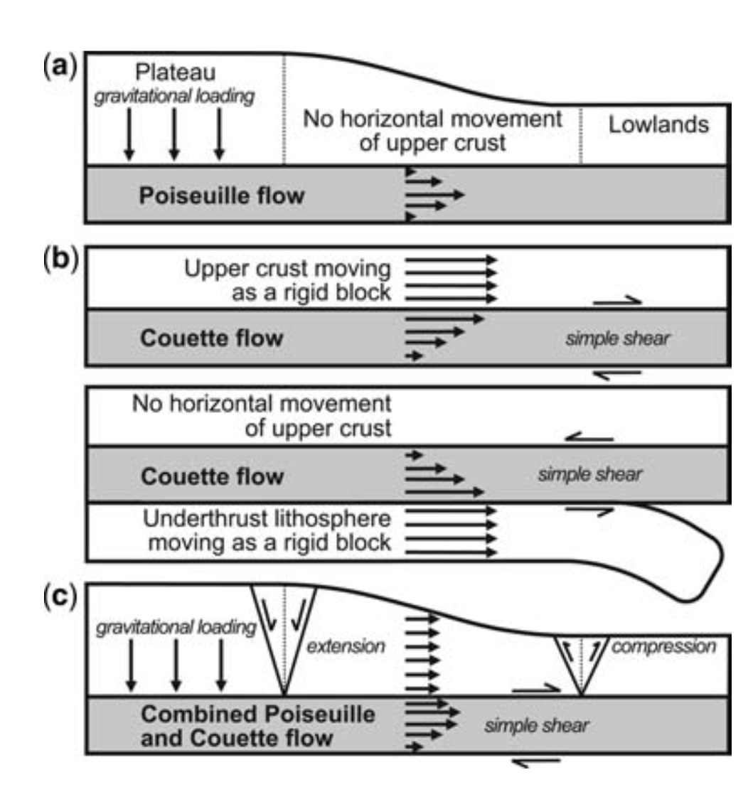
Definition of flow: Any viscous or plastic deformation may be regarded as flow
-
Definition of channel flow (this paper): Any flow in which a viscosity minimum at some depth strongly localizes horizontal material flow and partially or totally decouples flow at different depth
-
End-member models for flow: Poiseuille flow (pipe flow); Couette flow
-
Examples about previous applications of flow models to Tibet
-
*deudation to exhume the channel (flow)
-
-
图片:
Geophysical data bearing on crustal flow in Tibet
-
总结:
Methods to constrain partial melts or rheology, and review of past studies.
-
要点:
-
Introduce to 3 important surveys (Sino-French; Sino-US PASSCAL; INDEPTH): Types of data; Utilization and potential
-
Relief Data
-
wavelength → viscosity;
-
elastic thickness & Indian mantle suture;
-
weak lower crust in the eastern margin of the plateau
-
-
Geothermal measurements (recent magmatism):
-
Puga geothermal exploration: large variation over <25km → shallow heat source
-
Moho temperature
-
-
Seismicity cut-off at depth locates brittle-ductile and ductile-brittle transitions
-
95% earthquakes above 20km
-
crustal seismicity cut-off: brittle-ductile transition at 250-450℃
-
sub-Moho earthquakes at southern Tibet and Himalaya; temperature no more than 600-800℃
-
-
Seismic velocity and crustal thickness
-
Velocity: lithology, temperature and fluid distribution: SiO2↑ velocity↓; temperature↑ velocity↓; aqueous / magmatic fluids ↑ velocity↓
-
warmer mantle in the northern Tibet east of 85°: Sn attenuation & Rayleigh velocity
-
velocity contrast from south to north: 200-300℃ difference
-
SS-S differential traveltimes: variability
-
-
Lithospheric thickness: from S receiver function
-
Pnl modelling: laterally averaged crustal velocities (hundreds of kilometers)
- Low average Vp at all depth, comparing with global average
-
Receicer function / P-waveform modelling: high-velocity layer at the base of crust
- Greater Indian lower crust??
-
Receiver function
-
Low velocity zone below 20km at Lhasa Terrane?
-
High or normal Vp/Vs in Qiangtang?
-
-
Surface wave tomography
-
Low Vs compared with global values
-
Low Vs channel (mid-to-lower crustal) at Lhasa terrane; Less pronounced in Qiangtang as overall Vs here is low; Restricted south to IYS
-
Strongest low Vs & bright spots; Not restricted to the extensional grabens
-
-
Possible Processes: partial melts; partial eclogitization (High-Himalaya; Lhasa; northern margin);
-
Abrupt change in crustal thickness? (northern margin: Tarim and Qaidam basins) Comparing with Te (elastic thickness)?
-
Seismic Attenuation: evidence for high temperatures and partial melts
-
Northern Tibet: strong Sn attenuation in the mantle & strong attenuation in the crust (Lg, Pnl)
-
Yangbajin: strongest attenuation
-
IYZ: Q ~100; High Himalaya: Q ~300
- Comparison: 650 for stable central and eastern North America; 200 for tectonically active western North America
-
-
-
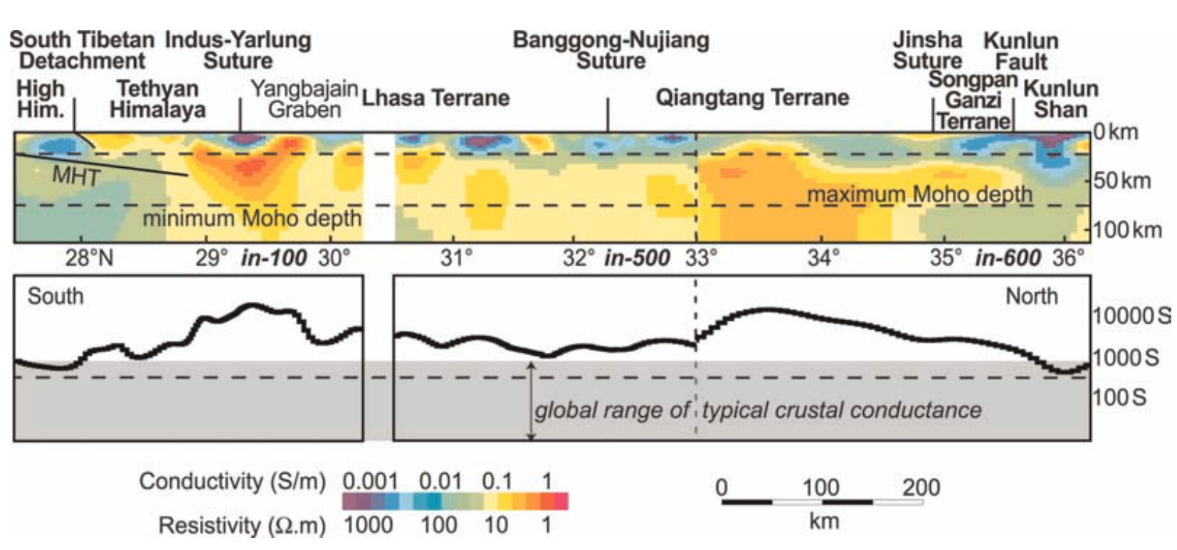
Conductivity, evidence for fluids and crustal weakening
-
High conductivity (Yangbajin, Yamdrok Tso): + high heat flow → magma
-
INDEPTH profiles: High crustal conductance; High conductivity below 15km; continuity of conductivity along Himalayan arc
-
Interconnected fluid along the grain boundaries of the rock?
-
Southern TP: The relationship bwtween inferred partial melt & north-south grabens? Southward flow?
-
Northern TP: Pressure dependence of dihedral angles; Fluids interconnection
-
-
Seismic Anisotropy, evidence for past or present strain of mantle and crust
-
require flow or recrystallization under non-uniform stress; cannot determine whether an ongoing flow
-
Observations: SKS splitting; multilayer anisotropic receiver function inversion
-
SKS splitting:
-
arising from lithosphere mantle (mostly), because olivine in the mantle allows easy creation of strain-induced lattice prefferred orientation.
-
Cannot resolve delay times <5s due to long periods of SKS waves
-
southern Lhasa terrane / India craton: small or negligible SKS splitting
-
Qiangtang Songpan-Ganzi: large split times
-
-
INDEPTH-3: Jiangli fault, strong variation in crustal anisotropy
-
correlation distance
-
considerate anisotropy in the crust; time-integrated strain history;
-
brittle crust: open cracks or old metamorphic fabrics
-
mid / lower crust: active deformation superimposed on older strain fabrics
-
-
-
Observation: surface waves, large scale behavior of the crust
-
vertical slower than horizontal: near-horizontal reorientation of anisotropic minerals (micas?) during thinning of anisotropic layer
-
flattening flow
-
-
-
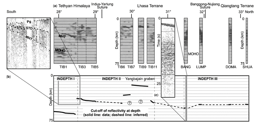
Seismic reflectivity, evidence for fluids and flow
-
bright-spots: unusually strong amplitudes; strong P-to-S cibversuibs; variation of amplitude with incidence angle of reflections (fluid > 15% porosity?)
-
Yangbajin: very likely to be hot enough to cause granitic melt, unless imaged very recent intrusion prior to cooling (unlikely); aqueous fluid, volumes too large to be easily maintained (unless deep fluid source exists)
-
will be exposed in the furture at the surface in a return channel flow??
-
-
pronounced lower-crustal reflectivity
-
tectonically imposed layering (shear zones, horizontal planar mafic intrusions)
-
mafic intrusion, less likely?
-
active ductile deformation and flattening foliation, extensional flow (likely)?
-
-
-
-
Indirect Methods:
-
Satellite Magnetic Low: Curie isotherm (550℃) ?
-
alpha-beta quartz transition → seismic reflector → 700~800℃ ?
-
Xenoliths
-
Pn tomography → Uppermost mantle temperature (more sensitive to lateral difference than absolute temperature)
-
volcanic events, adajutes
-
geodynamic modelling: kinematic or thermal-mechanical models
-
-
-
图片:

Physical properties inferred from geophysical observations
-
总结:
Flow models in southern or northern Tibet.
Evidences supports or disapproves flow models.
-
要点:
-
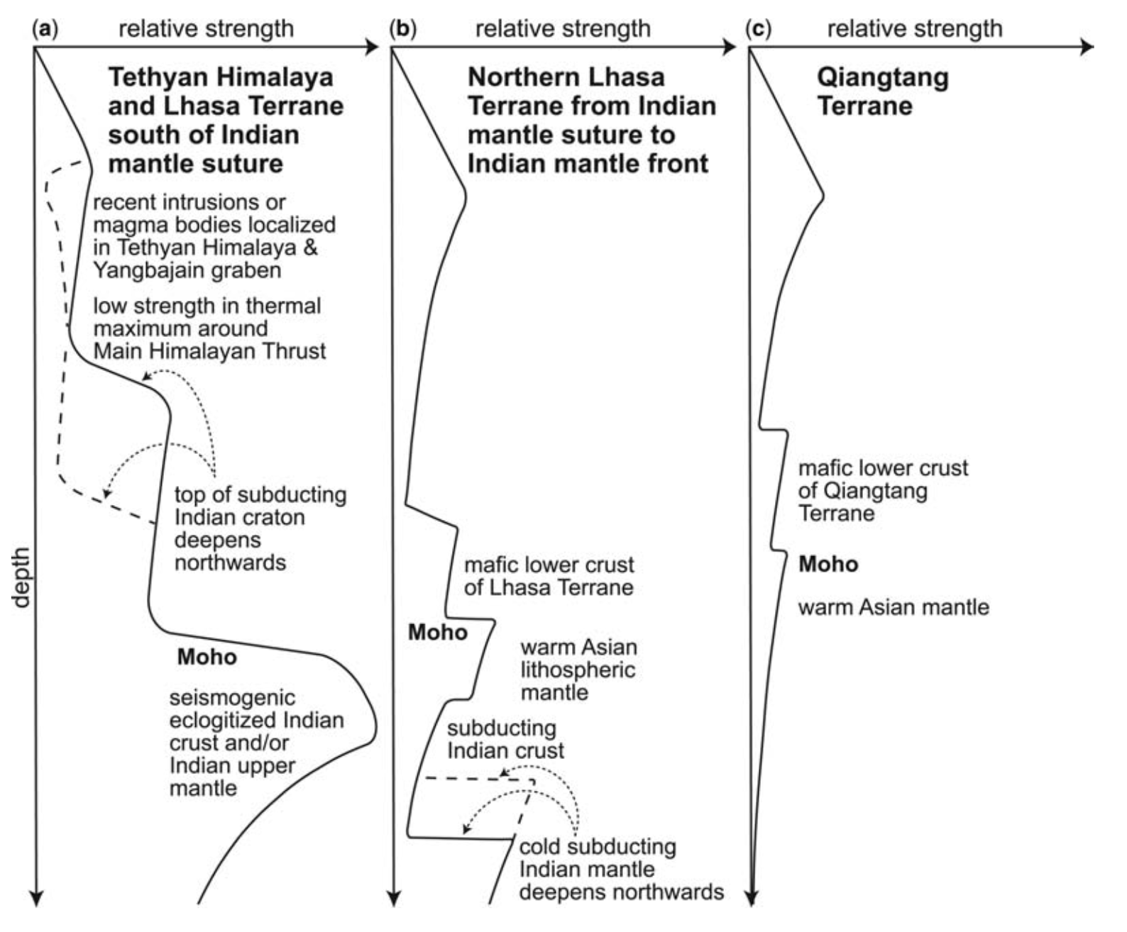
Inferred vertical strength profiles
-
southern Tibet: channel, ductile process
-
Tethyan Himalaya: middle crust strength minimum
-
Helium emission, thin zone of warmer Asian mantle
-
-
northern Tibet: less clear-cut
-
crust, weak; upper mantle, low Vs, strong attenuation
-
Removal of lithosphere?
-
Strong anisotropy; Impedance decrease
-
-
-
Inferred vertical velocity profiles
-
southern Tibet
-
GPS: surface moving NNE, with respect to Eurasia
-
Underthrusting: lower lithosphere move at similar direction
-
Similar focal mechanisums in south Tibetan upper crust and upper mantle
-
erosion: moving many marterials from Himalaya
-
Presume: the mountain front is not rapidly migrating northwards due to erosional retreat → needs replenishment (channel flow, thrust wedging) → advecting material southwards from Tibet to Himalayan font
-
southernmost Tibet: reduced nothward velocity in the middle crust, relative to upper crust or upper mantle (channel flow, Poiseuille form, Couette component)
-
Jiali Fault?
-
-
-
North of Jiali fault:
-
GPS: eastward velocity, continuity → more-distributed east-west extension
-
strain field: correlation of surface strain field with the mantle strain field → similar boundary conditions? coupling?
-
Couette-type component driven by the strong upper crust?
-
Northern boundary: mirror image of the Himalayan thrust front, low erosion rates prevents the emergence of a channel flow
-
-
Evaluation of existing channel flow models: southern Tibet:
-
mid-to-lower crust; south-directed to compensate for orographic exhumation?
-
Works from isotopic
-
Continuing coeval motion of MCT and STD; whether STD merging with the MCT at depth
-
-
Evaluation of existing channel-flow models: northern and eastern Tibet
-
modelling; geohistory
-
upper crust stronger
-
decoupling
-
-
-
-
图片:
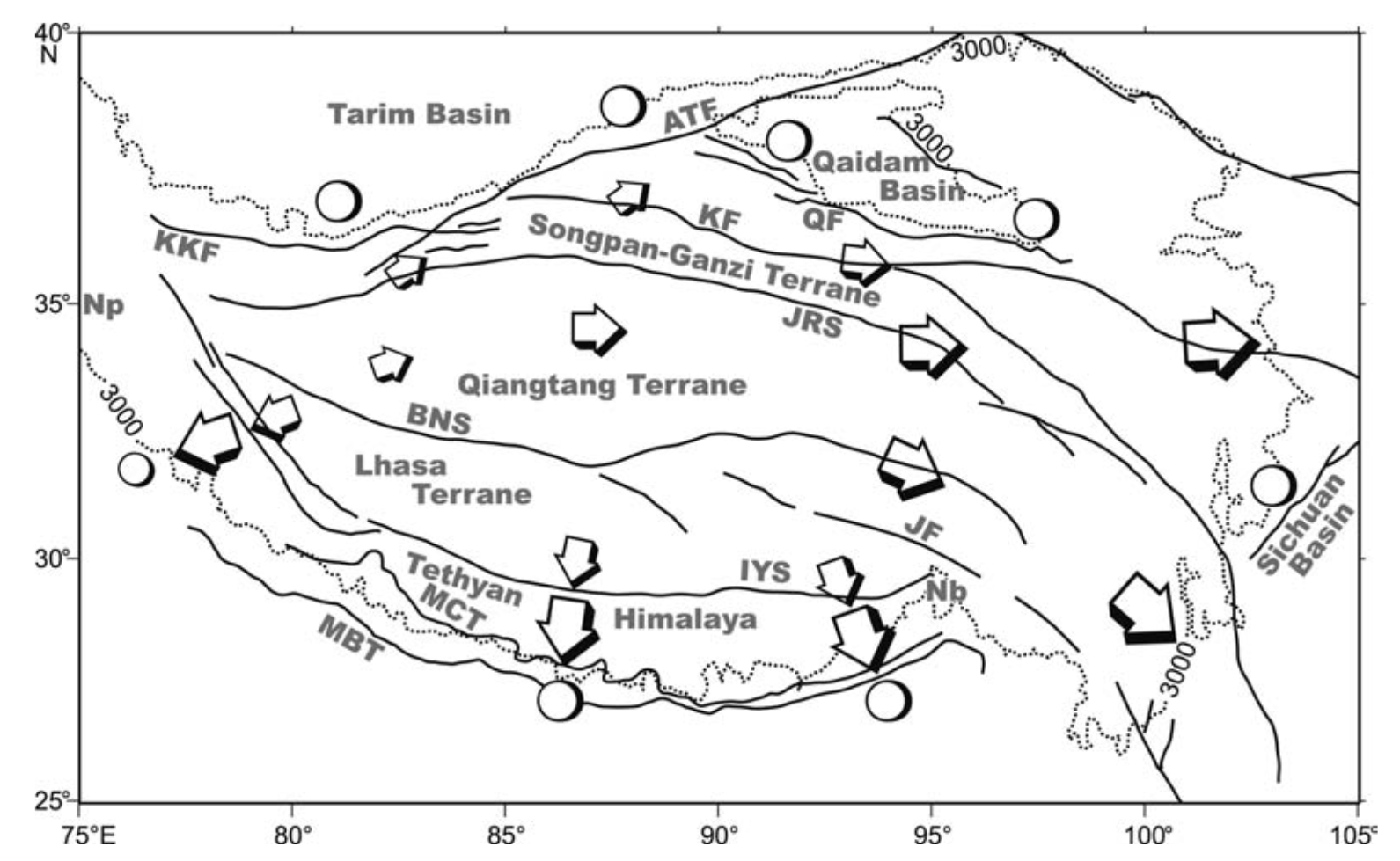
Summary
-
总结:
Liquid weaken the middle and lower crust
Southern Tibet: Indian underthrusting, south-directed flow of the middle crust (Poiseuille-type)
Northern and eastern Tibet: flow patterns less certain, weakly coupled flow, both Poiseuiller- and Couette-type flow.